|
|
|
RETURN TO MAIN PAGE |
|
| for Windows 10, 8, 7, Vista and XP, 32/64-bit | from www.mcrenox.com.ar | Mc & RENOX technologies | |
| www.mcrenox.com.ar - Software Development - by David Jorge Aguirre Grazio | 32-bit, 64-bit, x86, x64, Windows 7, Windows Vista, Windows XP | ||
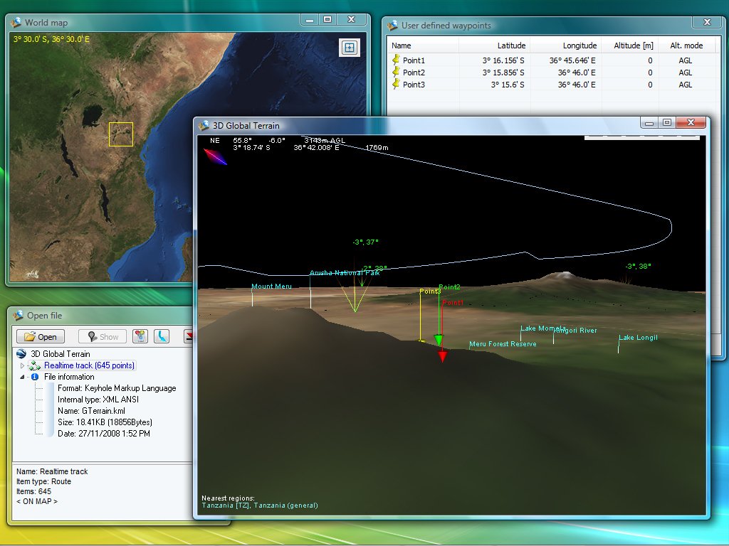
| 3D Global Terrain - global topography and imagery | ||||||||||||
|
|
|
|||||||||||
3D Global Terrain is the only
OFF-LINE 3D platform that combines NASA imagery generated from Blue Marble
project, elevation data from Shuttle Radar Topography Mission and more than
6.5 million of land markers with Cities and Points of Interest into a relatively
small but powerful worldwide platform. GTerrain will allow you to visit
any place in the world, know the general topography, and load and display
your Waypoints, Routes and Tracks from many file formats.
|
||||||||||||
| GPS Converter - multi-format converter | ||||||||||||
|
|
|
|||||||||||
| GPSconverter converts Waypoints, Tracks, and Routes from/to any file format for GPS receiver or mapping program. It also has powerful manipulation tools for such data. Note that you can select specific data and convert it among data types (ej: waypoints to route, tracks to waypoints, etc.) making it a convenient for professional use. | ||||||||||||
| Convert points from KMZ/KML to GPX and vice versa | [NEW VERSION] | |||||||||||
|
|
GE2GPX GPX2GE |
|||||||||||
|
Two useful tools to transfer waypoints, routes and tracks between KMZ/KML
and GPX format for your GPS. GE2GPX
Screenshot
or YouTube
demonstration video
GPX2GE converts points from your GPS (in GPX format, downloaded using any software provided by your GPS's manufacturer) to KMZ or KML. GPX2GE
Screenshot
or YouTube
demonstration video
|
||||||||||||
| World POI Database, large database with 12,026,386 of places | [NEW] [FREE] | |||||||||||
|
|
|
|||||||||||
| A very large off-line database
with 250 countries, 4,780,255 cities and 7,246,131 points of interest (47,390
cities in the free version), including country name, country code (ISO 3166),
city name, region, latitude, longitude and flag. In addition, WorldPOIdb
has a powerful search engine enabling you to find cities or places by keyword,
and gives you the ability to export waypoints of your places in KML format
(Keyhole Markup Language). Screenshot In addition, you can buy the raw database in CSV (tab delimited) or SQL format for use in your own applications. Click HERE for more information. |
||||||||||||
| TomTom Navigator OV2 to KMZ or GPX converter | ||||||||||||
|
|
|
|||||||||||
| Ov22Gps converts Waypoints
from TomTom Navigator (OV2) to KMZ or GPX format in a few steps. Screenshot |
||||||||||||
| KMZ to TomTom Navigator (OV2) converter | ||||||||||||
|
|
|
|||||||||||
| Ge2Ov2 converts Waypoints,
Routes and Tracks from KMZ or KML to TomTom Navigator overlay (OV2) file
in a few steps. Screenshot |
||||||||||||
| Magellan MapSend (WPT/TRK) to KMZ or GPX converter | ||||||||||||
|
|
|
|||||||||||
| MapSend2GPS converts Waypoints,
Routes and Tracks from Magellan MapSend files (WPT and TRK) to KMZ or GPS
Exchange Format (GPX) in a few steps. Screenshot |
||||||||||||
| Palm Desktop ABA to KMZ or GPX converter | ||||||||||||
|
|
|
|||||||||||
| Aba2Gps converts Waypoints
from Palm Desktop file format (ABA address files) to KMZ or GPS compatible
format (GPX) in a few steps. Screenshot |
||||||||||||
| KMZ/KML to SUUNTO (SDF) converter | ||||||||||||
|
|
|
|||||||||||
| Ge2Suunto converts Waypoints,
Routes and Tracks from KMZ or KML to SUUNTO (SDF) data file in a few steps
for easy upload to Suunto PC software (for example Suunto Trek Manager). Screenshot |
||||||||||||
| Garmin GPI to KMZ or GPX converter | ||||||||||||
|
|
|
|||||||||||
| Gpi2Gps converts Waypoints
from Garmin GPI file format (i.e. Garmin POI Loader) to KMZ or GPS compatible
format (GPX) in a few steps. Screenshot |
||||||||||||
| KMZ to KML converter and vice versa | [NEW VERSION] | |||||||||||
|
|
|
|||||||||||
| This application converts files from KMZ to KML and KML to KMZ. | ||||||||||||
| Global Weather 3D | [FREE] | |||||||||||
|
|
|
|||||||||||
Global Weather 3D gives you
the possibility to explore the entire world's weather using a very realistic
3D globe. Taking advantage of the most powerful graphics techniques using
OpenGL, you will find an interactive and exciting experience browsing global
clouds in real time (every hour) using two different cloud visualization
modes, "real photo" and "colorized clouds". In addition, Weather3D has four
different Earth's surface modes (normal texture, detailed texture, non-textured
and real-time day/night showing sun and moon positions) including countries
boundary and names.
|
||||||||||||
| Sun and Moon world map | [FREE] | |||||||||||
|
|
|
|||||||||||
| This application shows a world
map with the position of the Sun and Moon in real-time or in a specific
date. In addition, you can see in real-time or accelerated-time the Sun and Moon in movement around the Earth. Screenshot |
||||||||||||
| Quick Weather, Gadget or application for Windows | [FREE] | |||||||||||
|
|
|
|||||||||||
| QWeather shows the current
Satellite images (sky and cloud conditions) (440x300 pixel). The easiest
and quickest way to view the current world wide images from The Weather
Channel updated every 3 hours. In addition the program can animate the last
12 maps already downloaded. Screenshot |
||||||||||||
| Airways to KMZ format | ||||||||||||
|
|
|
|||||||||||
| Using Aw2Ge you can find realistic air routes between airports around the world and export it in KMZ format. | ||||||||||||
| Heading and Distance calculator | [FREE] | |||||||||||
|
|
|
|||||||||||
| This application calculates
the great circle distance between any two points and the initial course
(heading) on the great circle route. You can enter the latitude and longitude or just select the starting and ending cities (380 cities available at the moment). Screenshot |
||||||||||||
| GTerrain - The Game | [FREE] | |||||||||||
|
|
|
|||||||||||
GTerrain - The Game, using
3D Global Terrain engines, this multi-player game take advantage of its
real-world characteristics and using LAN network connection will allow you
to play and have fun with your friends all interacting together in this
virtual world attacking and defending your base and aircrafts.
|
||||||||||||
|
||||||||||||
| Alan Map500 tracklogs (.trl) waypoints and routes (.wpr); Cambridge/Winpilot glider software; CarteSurTable data file; Cetus for Palm/OS; CoastalExplorer XML; CompeGPS data files (.wpt .trk .rte); CoPilot Flight Planner for Palm/OS; cotoGPS for Palm/OS; Dell Axim Navigation System (.gpb); DeLorme .an1 (drawing); DeLorme GPL; DeLorme Street Atlas Plus, Route; DeLorme XMap HH Native .WPT; DeLorme XMap/SAHH 2006 Native .TXT; DeLorme XMat HH Street Atlas USA .WPT (PPC); EasyGPS; FAI/IGC Flight Recorder Data Format; Fugawi; G7ToWin data files (.g7t); Garmin 301 Custom position and heartrate; | ||||||||||||
| Garmin Logbook XML; Garmin MapSource gdb, mps; Garmin PCX5; Garmin POI database; Garmin Points of Interest (.gpi); Geocaching.com .loc; GeocachingDB for Palm/OS; Geogrid Viewer tracklogs (.log); GEOnet Names Server (GNS); GeoNiche .pdb; Keyhole Markup Language; GpilotS; GPS TrackMaker; GpsDrive Format, Tracks; GPSman; GPSPilot Tracker for Palm/OS; GPX XML; HikeTech; Holux (gm-100) .wpo; HSA Endeavour Navigator export File; IGN Rando track files; Kartex 5 Track, Waypoint; Kompass (DAV) Track (.tk) Waypoints (.wp); KuDaTa PsiTrex text; Lowrance USR; Magellan Mapsend; | ||||||||||||
|
||||||||||||
| Magellan NAV Companion for Palm/OS; Magellan SD files (as for eXplorist, Meridian); Map&Guide 'TourExchangeFormat' XML; Map&Guide to Palm/OS exported files (.pdb); Mapopolis.com Mapconverter CSV; MapTech Exchange Format; Microsoft AutoRoute 2002 (pin/route reader); Microsoft Streets and Trips (pin/route reader); Microsoft Streets and Trips 2002-2007;Motorrad Routenplaner (Map&Guide) .bcr files; MS PocketStreets 2002 Pushpin; "MTK Logger (iBlue 747...) Binary File Format"; National Geographic Topo .tpg (waypoints); Navicache.com XML; Navigon Mobile Navigator .rte files; | ||||||||||||
|
||||||||||||
| Navitrak DNA marker format; NetStumbler Summary File (text); NIMA/GNIS Geographic Names File; NMEA 0183 sentences; Nokia Landmark Exchange; OziExplorer; PathAway Database for Palm/OS; Quovadis; Raymarine Waypoint (.rwf); Sportsim track files (part of zipped .ssz files); Suunto Trek Manager (STM) .sdf; Suunto Trek Manager (STM) WaypointPlus; Swiss Map # (.xol) format; TomTom Itineraries (.itn); TomTom POI file (.asc); TomTom POI file (.ov2); TopoMapPro Places File; TrackLogs digital mapping (.trl); U.S. Census Bureau Tiger Mapping Service; Vito Navigator II tracks; Vito SmartMap tracks (.vtt); WiFiFoFum 2.0 for PocketPC XML; Wintec WBT-100/200 Binary File Format; Wintec WBT-201/G-Rays 2 Binary File Format;Yahoo Geocode API data; | ||||||||||||
|
||||||||||||
| Copyright 2005-2023 by David Aguirre Grazio - Mc & RENOX technologies - www.mcrenox.com - www.mcrenox.com.ar |